About
GIS LiDAR Mobile Mapping Photogrammetry BIM
Careers Contact Get a Quote →
Welcome to Vector Mapping

Mapping the World
with Precision.

We deliver high-precision geospatial, GIS , LiDAR, Mobile mapping, BIM and AI-integrated mapping solutions that empower industries to plan, build, and operate with confidence.

About Banner
99% Data Accuracy Rate
10+ Years of Field Expertise
200+ Projects Delivered
1+ Lakh SQ.KM Mapped

The Geospatial Partner Behind the World's Most Demanding Projects

Our AI-integrated workflows ensure faster turnaround, higher consistency, and smarter outputs.

Vector Mapping is a specialist geospatial and mapping solutions company delivering precision spatial intelligence to infrastructure developers, engineering firms, utilities operators, and government authorities across the globe.

With over 1,000,000 sq. km of geospatial data processed and mapped, we have built a reputation for accuracy, reliability, and technical excellence.

  • GIS Databases & Spatial Intelligence
  • LiDAR Point Cloud Processing
  • Mobile Mapping
  • Photogrammetry & 3D Models
  • BIM-ready Data
Learn More →
ABOUT US

Built for precision and scale

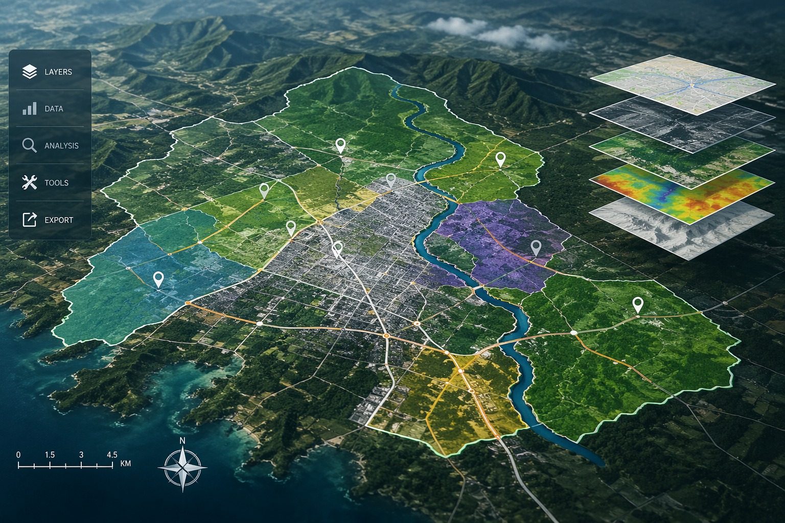
End-to-end geospatial services with clear deliverables, accurate data, and production-ready mapping outputs.

GIS mapping layers over terrain

GIS

Decision-ready spatial intelligence for infrastructure and utilities.

  • Network mapping
  • Land boundaries
  • Utility mapping
Explore →
Colorized LiDAR terrain map

LiDAR

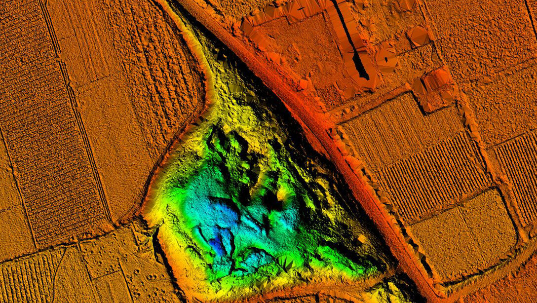
High-precision point cloud processing and terrain modeling.

  • Point cloud classification
  • DTM / DSM
  • Corridor analysis
Explore →
Digital city and corridor mapping

Mobile Mapping

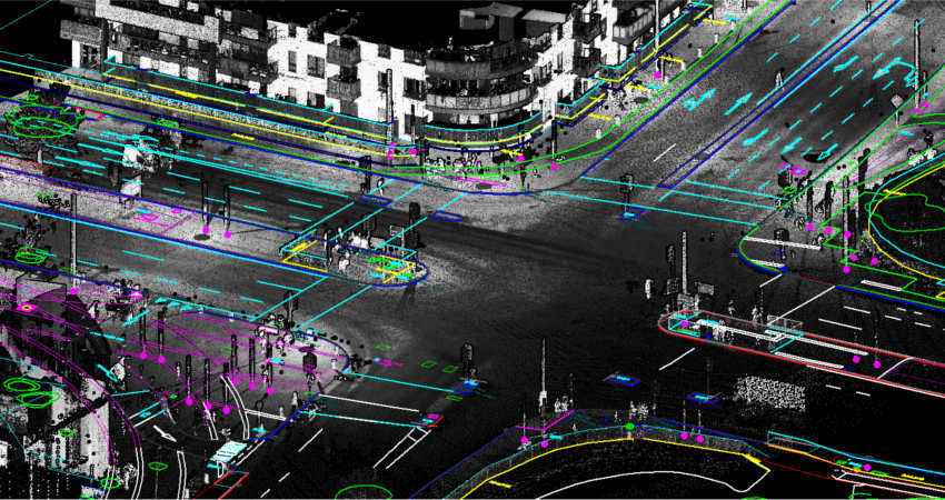
Fast corridor intelligence using mobile LiDAR systems.

  • Highway assets
  • Road condition
  • Urban mapping
Explore →
Global geospatial network visualization

Photogrammetry

Aerial imagery into accurate maps and 3D models.

  • Orthomosaic
  • 3D modeling
  • Survey mapping
  • DTM/DSM
Explore →
Building information modelling and digital construction data

BIM

BIM-ready models connecting survey, design, and construction workflows.

  • Scan-to-BIM
  • As-built modelling
  • Asset information
Explore →
Why Clients Choose Vector Mapping

Accuracy, expertise, and end-to-end delivery

End-to-End Capability
100%
Complete geospatial workflow — from field data capture and sensor fusion to final CAD, GIS, and BIM deliverables. No hand-offs. No gaps.
International Standards
ISO / OGC
All deliverables aligned with ISO, OGC, and client-specific standards — ensuring seamless integration with your workflows and tools.
AI-Driven Efficiency
40%
Faster turnaround using AI-powered processing pipelines — without compromising engineering-grade precision.
01
End-to-End Capability
From field data capture and sensor fusion to final CAD, GIS, and BIM deliverables — we manage the entire geospatial workflow under one roof, ensuring consistency from start to finish.
02
International Standards, Every Time
All our outputs follow international geospatial standards such as ISO and OGC, along with project-specific client specifications — ensuring compatibility with your existing systems.
03
AI-Powered Speed and Accuracy
Our integrated AI workflows reduce turnaround time by up to 40% while maintaining the precision tolerances required for infrastructure and engineering projects.
04
Experienced Field and Processing Teams
Our multidisciplinary team includes aerial survey pilots, licensed surveyors, GIS analysts, BIM specialists, and remote sensing engineers — delivering deep expertise on every project.
HOW WE WORK

From brief to delivery — five clear steps

01
Consultation
We begin with a detailed discovery session to understand your project scope, objectives, accuracy requirements, and delivery timelines.
02
Planning & Proposal
Our experts design the optimal data acquisition strategy, select the right tools and technologies, and provide a transparent, fixed-price proposal.
03
Data Acquisition
Field teams and aerial platforms capture high-precision data using GNSS, UAVs, mobile mapping systems, and LiDAR — all under strict quality control.
04
Processing & Analysis
Proprietary workflows combined with industry-standard software transform raw datasets into accurate, analysis-ready geospatial outputs.
05
Delivery & Support
Final deliverables are provided in your preferred formats, supported by post-delivery assistance, training, and long-term maintenance options.

Geospatial Data Used in Various Industries

To increase high levels of productivity, Vector Mapping provides point cloud classification and geospatial data services for various industries.

Smart City & Urban Development

Transport and Navigation

Irrigation, Water & Disaster Management

Defence & Security

Forest Management

Utilities (Power / Telecom / Water)

Infrastructure

Mining

Oil & GAS Pipelines

Flood Mapping

Environment

Highway & Road Survey

Land Cover Classification

Landslide Risk Assessment

Everything you need to know before getting started

We support LAS, LAZ, GeoTIFF, DWG, IFC, Shapefile, and most raster/vector formats. Our team confirms compatibility before project kickoff.
Yes, we work globally with fully remote processing and delivery workflows.
Most projects are completed within 5–15 business days depending on complexity.
We follow ISO, OGC, and client-specific geospatial standards for all deliverables.
Yes, we ensure strict data confidentiality and sign NDAs before any data exchange.
Yes, our AI-integrated workflows are built for large-volume and long-term projects.

Ready to map your next project?

Talk to our geospatial experts and get a tailored solution and competitive quote within 24 hours.

Request a Quote Call Us Now